- Cart - 0 items
Cart is Empty.
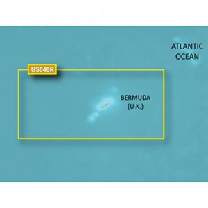
BlueChart® g3 Vision® HD - VUS048R - Bermuda - microSD™/SD™
Coverage:
Provides coverage of Bermuda detailing Saint George's Island and Harbour, Harrington Sound, Somerset Island, the Great and Little Sounds, Hamilton Island, and Castle Harbour.
Premier Coastal Navigation Charts
$297.24
BlueChart® g3 Vision® HD - VUS048R - Bermuda - microSD™/SD™
Coverage:
Provides coverage of Bermuda detailing Saint George's Island and Harbour, Harrington Sound, Somerset Island, the Great and Little Sounds, Hamilton Island, and Castle Harbour.
Premier Coastal Navigation Charts
BlueChart® g3 Vision® HD - VUS048R - Bermuda - microSD™/SD™
Coverage:
Provides coverage of Bermuda detailing Saint George's Island and Harbour, Harrington Sound, Somerset Island, the Great and Little Sounds, Hamilton Island, and Castle Harbour.
Premier Coastal Navigation Charts
Related Products
Copyright © TechBuys All Rights Reserved.