- Cart - 0 items
Cart is Empty.
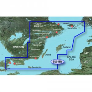
BlueChart® g3 HD - HXEU046R - Oregrund Aland to Malmo - microSD™/SD™
Coverage:
Detailed coverage of the Southeast coast of Sweden from Oregrund to Copenhagen, Den. Includes detailed coverage of Stockholm and Nykoping, and lakes Sommen, Nommen, and Helgasjon, as well as coverage of the lower Dalalven from Gysinge to Soderfors. Also includes detailed coverage for the islands of Gotland, Oland, and Bornholm, Aland and surrounding islands.
Unparalleled Coastal Chart Coverage
$115.74
BlueChart® g3 HD - HXEU046R - Oregrund Aland to Malmo - microSD™/SD™
Coverage:
Detailed coverage of the Southeast coast of Sweden from Oregrund to Copenhagen, Den. Includes detailed coverage of Stockholm and Nykoping, and lakes Sommen, Nommen, and Helgasjon, as well as coverage of the lower Dalalven from Gysinge to Soderfors. Also includes detailed coverage for the islands of Gotland, Oland, and Bornholm, Aland and surrounding islands.
Unparalleled Coastal Chart Coverage
Related Products
Copyright © TechBuys All Rights Reserved.